![]()
Funded by NASA
Introduction
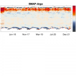
The purpose of the Soil Moisture Active Passive (SMAP) validation report is to document measurement uncertainty characteristics, including residual errors in the latest version (V5.0) of the sea surface salinity (SSS) data product provided by Remote Sensing Systems (RSS), which is sponsored by the NASA Ocean Salinity Science Team. This dataset is available at www.remss.com and was released in March of 2022. This release should not be confused with the SMAP SSS data published by NASA’s Jet Propulsion Laboratory (JPL). On this webpage, we highlight results from the SMAP V5.0 validation report.
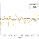
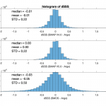
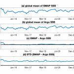
We document the improvement from V4.0 to V5.0 by comparing each version of SMAP data with Argo and additional in situ data. Here we use 87 months of data (from April 2015 to June 2022) for validation analysis. One major improvement for V5.0 is that Advanced Microwave Scanning Radiometer 2 (AMSR-2) TB measurements for sea-ice flagging and sea-ice side-lobe correction are directly ingested instead of using an external sea-ice concentration product as in the earlier versions (Meissner et al. 2022; Meissner and Manaster, 2021). The changes to sea ice correction allow salinity retrieval closer to the sea-ice edge and help the detection of large icebergs in the polar regions. It should be noted that the matchup statistics between SMAP and in situ observations not only include SMAP SSS uncertainty, but also the sampling differences (e.g., spatial scales) between SMAP data (averaged over SMAP footprint) and the point-wise-in-situ measurements.
Validation analysis starts with SMAP Level 2 (L2; science data in swath coordinates and matching ancillary data) data evaluation followed by Level 3 (L3; gridded ¼ degree) monthly average analysis. Salinity measurements are on the practical salinity scale (PSS-78), technically a dimensionless number, but in some figures labeled as practical salinity units (psu).
The near-surface in situ salinity data used here are from EN.4.2.2 with Gouretski and Reseghetti (2010) bias corrections applied and include Argo data as well as additional in situ data (supported by the Met Office Hadley Centre Climate Programme; Good et al., 2013). Since EN4 relies extensively on Argo data, “Argo” is used interchangeably with “EN4”.
We also complete the same matchup analysis with Soil Moisture and Ocean Salinity (SMOS) data for comparisons. The SMOS L2 SSS products used here are L2 OS Version 700 released by European Space Agency (ESA; Reul et al., 2022; Boutin et al., 2018). SMOS L3 data is provided by Centre Aval de Traitement des Donnees SMOS (CATDS, 2022).
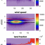
Level 2 Validation Results
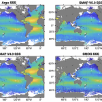
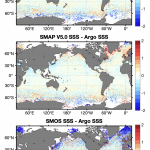
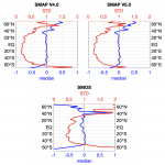

Level 3 Validation Results
References:
Boutin J., Vergely J.L., Marchand S., D Amico F., Hasson A., Kolodziejczyk Nicolas, Reul Nicolas, Reverdin G., Vialard J. (2018), New SMOS Sea Surface Salinity with Reduced Systematic Errors and Improved Variability. Remote Sensing of Environment, 214, 115-134. Publisher s official version : http://doi.org/10.1016/j.rse.2018.05.022 , Open Access version : http://archimer.ifremer.fr/doc/00441/55254/
CATDS (2022). CATDS-PDC L3OS 3Q mixed – Debiased average 10 days & monthly salinity field product from SMOS satellite (mixed orbits). CATDS (CNES, IFREMER, LOCEAN, ACRI). http://dx.doi.org/10.12770/0f02fc28-cb86-4c44-89f3-ee7df6177e7b
Good, S. A., Martin, M. J., and Rayner, N. A. (2013), EN4: Quality Controlled Ocean Temperature and Salinity Profiles and Monthly Objective Analyses with Uncertainty Estimates, J. Geophys. Res. Oceans, 118, 6704– 6716, doi:10.1002/2013JC009067.
Gouretski, V., and Reseghetti, F. (2010), On depth and temperature biases in bathythermograph data: development of a new correction scheme based on analysis of a global ocean database. Deep-Sea Research I, 57, 6. doi: https://doi.org/10.1016/j.dsr.2010.03.011
Meissner, T., and Manaster, A. (2021), SMAP Salinity Retrievals near the Sea-Ice Edge Using Multi-Channel AMSR2 Brightness Temperatures. Remote Sens. vol. 13, pp. 5120. https://doi.org/10.3390/rs13245120.
Meissner, T., Wentz, F.J., Manaster, A., Lindsley, R., Brewer, M., Densberger, M. (2022). Remote Sensing Systems SMAP Ocean Surface Salinities [Level 2C, Level 3 Running 8- day, Level 3 Monthly], Version 5.0 validated release. Remote Sensing Systems, Santa Rosa, CA, USA. Available online at www.remss.com/missions/smap, doi: 10.5067/SMP50-2SOCS and 10.5067/SMP50-3SMCS
Reul et al., (2022), SMOS level 2 sea surface salinity product release note. https://earth.esa.int/eogateway/documents/20142/37627/SMOS-Level-2-Sea-Surface-Salinity-release-note-v700.pdf