
Earth & Space Research continually performs extensive calibration and validation with both 15m drogued drifters (World Wide Drifter Buoy Deployment data, http://www.aoml.noaa.gov/phod/dac/gdp_doc.html) and with moorings from the global network of OceanSITES fixed location observations http://www.oceansites.org/.
To perform the comparison between drifting buoys and OSCAR, velocities and locations from the buoys are binned into daily averages. OSCAR velocities are interpolated onto each point of daily binned data. The zonal and meridional components are then directly compared to each other. This choice in method for comparing vector values is based on the fact that many parts of the ocean have a predominantly zonal flow.
The figures below shows the results of the correlation between OSCAR and drifters for both of the zonal and meridional components. Datapoints are collected into 2 degree bins for the entire data span, and statistics are computed for within each bin.
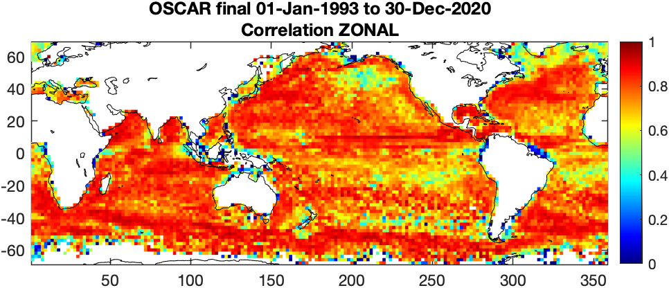
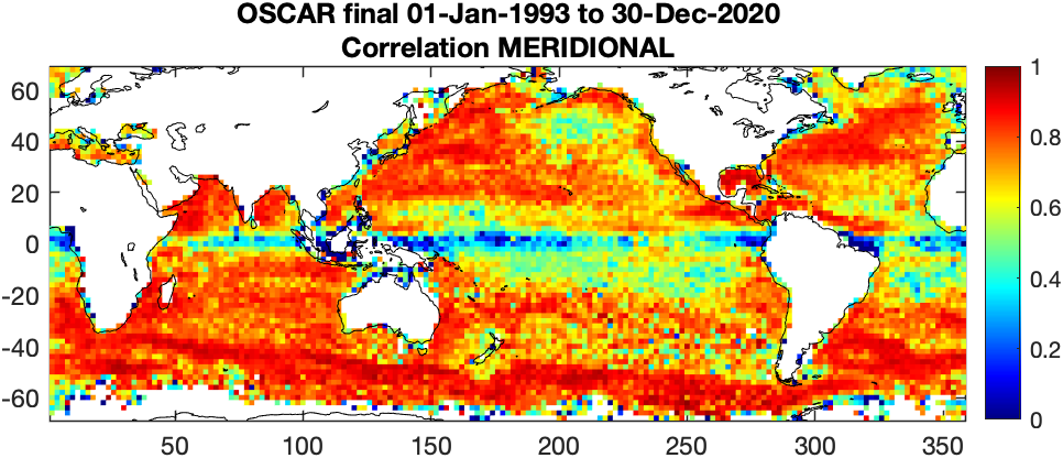
Most areas have high correlations, with values above 0.9 in many regions. Known problem areas fall in 3 main categories: 1) eddy-dead regions such as the Alaska Gyre, 2) the meridional component around the equator, and 3) near coasts. In the first case, the dominant signal to OSCAR comes from the slow large-scale flow, and therefore the signal to noise is too high for accurate comparisons with point drifter measurements. In the second, since the geostrophic flow is based off of gradients of velocities, in this area the flow is so strongly zonal that the x-gradient is very weak. In the third case, model is not accurate very close to coastlines (or ice) and source satellite signals can be corrupted close to land. It depends on coastlines, but generally OSCAR currents are inaccurate within 100 km of the coast. In all areas, OSCAR currents are estimated through a simplified diagnostic model of the surface circulation, and as such have some limitations. Notably, local acceleration and non-linearities are not represented, and the geostrophic assumption is not valid right at the equator. Any inherent errors in the source datasets will also impact the quality of the velocities. Examples are high winds, rain, residual orbit errors, optimal interpolation errors, and sparse coverage, to name a few.
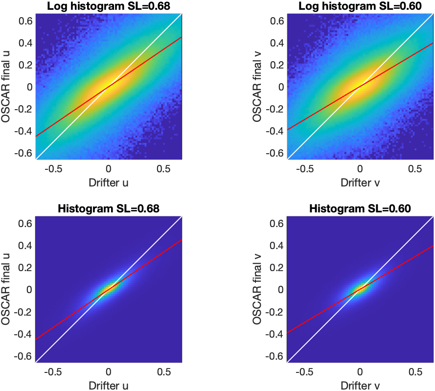
Smoothing inevitably occurs in the creation of the regular gridded source data as well as during the calculation of spatial gradients (for geostrophic and thermal wind components only). This sort of indirect smoothing effect is lessened in this v2.0 compared to 1/3° OSCAR and significantly from the 1° OSCAR product. Specifically, any gridding of SSH will smooth out eddies and lose the small scales. As such, the speeds in OSCAR are consistently lower than the speeds observed by the drifters. Below are scatterplots of the zonal and meridional component comparisons for the entire dataset, also provided on a log scale. The slope of the line indicates the underestimation of the speeds, generally by 50-60%.
More validation information on the OSCAR third degree version of this product can be found in Dohan and Maximenko [7].
[7] Dohan, K., and N. Maximenko, (2010). Monitoring ocean currents with satellite sensors.